A powerful magnitude 7.7 earthquake struck central Myanmar on 28 March 2025 and ruptured the north–south trending Sagaing Fault in a way that shocked scientists and communities alike. The event caused widespread devastation and claimed thousands of lives. However, apart from the immediate human tragedy, researchers uncovered scientific lessons that may reshape global understanding of seismic hazards and risk assessment.
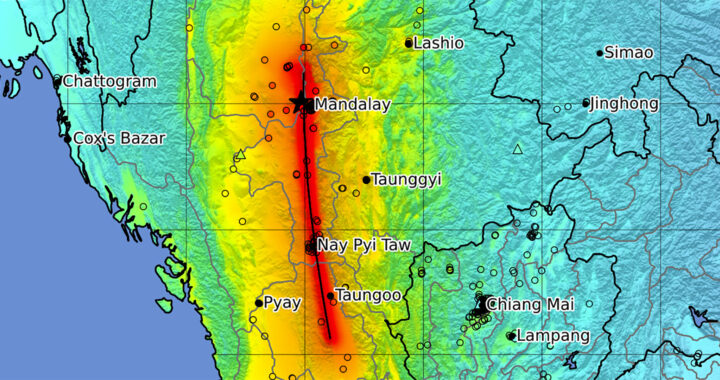
The Sagaing Fault has long been considered a mirror of the San Andres Fault in California. Both are characterized by their long length and straight strike-slip systems. Scientists believed the Myanmar earthquake would rupture a 300-kilometer seismic gap. This segment was thought overdue since 1893. However, the actual rupture extended over 500 kilometers. This suggests that such faults may behave in far more complex and unpredictable ways.
Satellite imagery provided the breakthrough in analyzing this unusual rupture. Researchers employed optical image correlation, a technique pioneered at the California Institute of Technology, to track ground displacements with extraordinary precision directly on the fault. Unlike radar interferometry, which can lose reliability near the fault or struggle with north–south motion, this approach delivered detailed maps of on-fault and near-fault deformation.
Measurements based on optical image correlation revealed an average of about three meters of offset between the two sides of the Sagaing Fault. The easter block specifically moved south relative to the western block. This displacement exceeded the accumulated slip deficit. It also demonstrated that earthquakes can release not only stored stress but also propagate far beyond historically defined segment boundaries in unpredictable cascades.
The rupture challenged the long-standing seismic gap hypothesis. Take note that this hypothesis assumes and somewhat predicts earthquakes occur when locked fault segments finally catch up with missing slip. While the anticipated gap did rupture, the quake spread to adjoining segments, including those that ruptured earlier in the twentieth century. This multi-segment behavior proves that earthquakes may cross boundaries once thought to be natural barriers.
Implications for hazard models are established. Current models often assume time-independent probabilities. These offered recurrence estimates across decades without reflecting real-time stress distribution. The 2025 Myanmar Earthquake demonstrated the need for physics-based and time-dependent models that incorporate recent slip observations and account for clustering, cascading ruptures, and complex segmentation along long strike-slip faults.
Note that the lessons extend beyond Myanmar. Because of its similarity to the Sagaing Fault, the San Andreas Fault in California may also be capable of rupturing across segments in manners not recorded historically. This likelihood implies the much-anticipated Big One could be larger, longer, and more disruptive than existing model-derived scenarios suggest. This also challenges preparedness strategies already placed in heavily populated regions.
The research, published in Proceedings of the National Academy of Sciences on 11 August 2025, was led by Solène L. Antoine and senior author Jean-Philippe Avouac, along with collaborators from New Zealand, China, and the United States. Their analysis underscores how innovative observation methods combined with updated modeling approaches can transform both scientific understanding and public planning for catastrophic earthquakes.
FURTHER READING AND REFERENCE
- Antoine, S. L., Shrestha, R., Milliner, C., Im, K., Rollins, C., Wang, K., Chen, K., and Avouac, J.-P. 2025. “The 2025 M w 7.7 Mandalay, Myanmar, Earthquake Reveals a Complex Earthquake Cycle with Clustering and Variable Segmentation on the Sagaing Fault.” Proceedings of the National Academy of Sciences. 122(33). DOI: 1073/pnas.2514378122